



Scottish researchers uncover untracked vessel threat
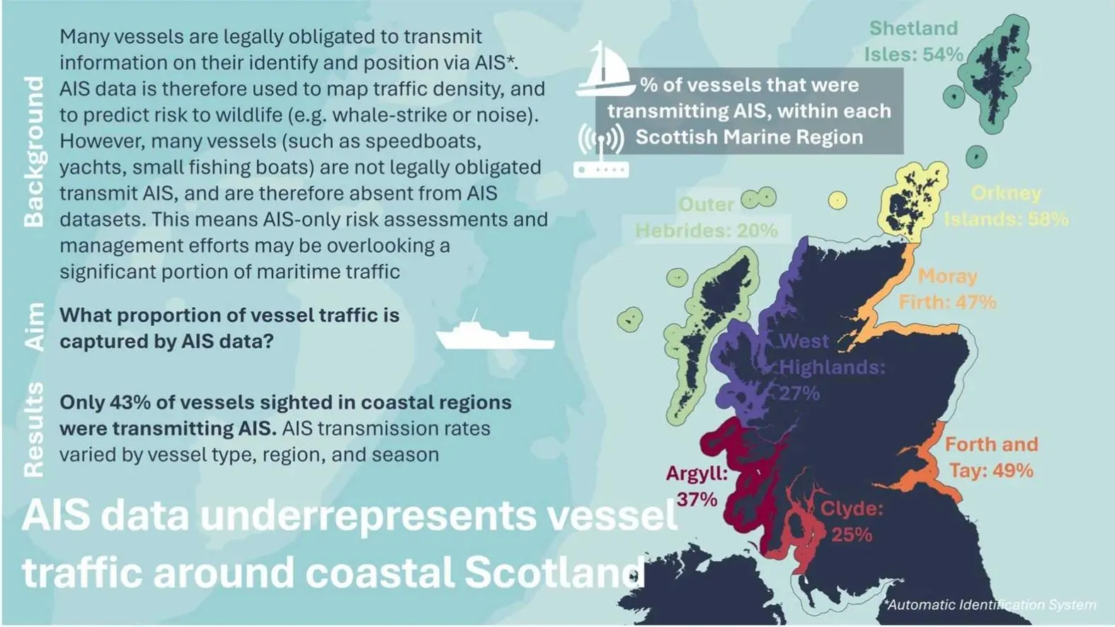
That’s according to a new study by Heriot-Watt University in Edinburgh, which found that only 43% of vessels within 10km of the Scottish coast broadcast an Automatic Identification System (AIS) signal, the global standard for vessel monitoring.
This means the majority of marine activity in these waters is effectively invisible to standard tracking tools.
“This data challenges the assumption that we can rely on AIS to tell us what’s really happening in our coastal seas,” said Dr Emily Hague, lead author of the study from Heriot-Watt’s School of Energy, Geoscience, Infrastructure and Society.
“In some areas, over 75% of vessel activity goes unrecorded.”
Navigating blind
The study, published in Marine Policy, relied on over 1800 hours of land and sea surveys conducted between 2019 and 2024, covered nine of Scotland’s 11 marine regions and showed huge regional and seasonal disparities in AIS visibility.
Much of the data was collected by citizen scientists from several conservation organisations, where volunteers were trained to follow a standardised method to survey and quantify ships.
The study highlighted significant regional variations. In the Outer Hebrides, only 20% of vessels observed were transmitting AIS data, despite the area being a hotspot for ecotourism, fishing and aquaculture.
The Orkney Islands showed a higher rate, with 58% of vessels broadcasting, but in the Forth and Tay, home to some of Scotland’s busiest ports, AIS coverage reflected true traffic only 8% of the time, raising questions about under-represented commercial and recreational traffic.
Smaller vessels, such as fishing boats under 15m, recreational craft and jet skis, did account for much of the missing data, but not all of it.
But the research doesn’t just highlight a gap, it offers a path forward, one that could also be used in other waters.
The authors suggest that where there are high volumes of non-AIS vessels, AIS data should be supplemented with other tracking methods, such as land-based observations and citizen science, to build a complete picture.
It points out that ideally, even smaller vessels should broadcast their position using AIS, although they’re not legally required to do so.
“With an improved understanding of the activities and movement of different types of vessels, marine planners and policymakers could tailor regulations to maximise their potential effectiveness,” said Dr Hague.
“The wider maritime sector could further benefit through improved safety and awareness.”
The study also recommends applying correction factors when using AIS to model coastal impacts, taking into account local vessel type, region and season.
Until universal tracking is possible, the researchers argue, such adjustments are crucial to avoid blind spots in maritime governance and any AIS-based risk assessments.
Related Articles
 ALTERNATIVE FUELS & LUBRICANTS
 GENERAL NEWS
 GENERAL NEWS