Electronic data for navigation and planning fires controversy
The whole ECDIS and electronic navigational chart (ENC) debate, and it has been quite some debate over the years, has been characterised by disagreements between the major providers of chart data. For many years this has been over how the considerable gaps between ‘official’ ENCs should be filled. Although the SOLAS solution was, and still is, to continue to use paper charts in such areas, this has always seemed rather a waste of the expensive and user-friendly ECDIS hardware on the bridge. UKHO (the United Kingdom Hydrographic Office) favoured a ‘dual-fuel’ solution, with its ARCS raster charts – effectively a paper Admiralty chart displayed on the ECDIS screen – while the Norwegian approach was based on commercial C-Map vector data, offering similar functionality to ENCs though without the full official standing.
As official ENC coverage has expanded so that now most of the major sea routes and ports are now well covered, this particular debate has been replaced by another on how the chart data is licensed and paid for. The UK and Norwegian factions agree on the main points, namely that the ultimate goal is full global coverage of ENCs from official sources, and that some form of ‘dynamic licensing’, where ships carry a full portfolio of ENCs, but only the charts they actually use are licensed and activated. And it is the mechanics of the latter that are currently proving controversial.
The Norwegian Hydrographic Service and its Primar subsidiary have backed an ingenious solution from Dutch company Datema, with which the ship carries a tracking device so that when it enters a particular chart cell, the license is automatically activated and the operator billed for that chart licence. Datema cites the system’s simplicity, its fairness (shipowners pay only for charts they actually use, when they use them, and the most economic licensing period is automatically applied) and safety (if a ship needs to divert for any reason then an up to date official chart is always available, and paid for when the ship enters the chart area).
So far so good, but the UKHO and its allies point out, quite reasonably, that some 70% of navigation is in the planning stage. The Datema/Primar system does not take this into account, and does not charge for using charts for planning – UKHO says this places no value on the use of charts for voyage planning, which it feels is wrong.
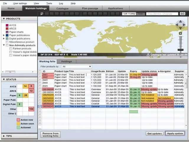
UKHO’s alternative is the recently-introduced Admiralty e-Navigator, described as an integrated digital catalogue, product viewer and passage planning tool for use at every stage of navigation and fleet management.
The e-Navigator organises, updates, and brings together all of the paper and digital information needed to plan safe voyages and simplify essential tasks, either onboard ship or ashore, using a simple and familiar Windows-style PC interface.
UKHO says that e-Navigator marks the first stage of its plans to help mariners and shipping companies meet the requirements of a rapidly changing commercial and compliance environment and to provide better decision making tools at every stage of planning and voyage execution – “a fundamental shift, from paper to digital, from protective to proactive navigation” according to UKHO chief executive Mike Robinson.
e-Navigator allows mariners to quickly plot a route and identify the most appropriate products needed to navigate that route safely and compliantly. It compares the products required with what the ship currently holds, and allows new products to be ordered if needed. New products can be accessed instantly and, if appropriate, transferred to the front of bridge ECDIS for the execution of the voyage.
As well as the Admiralty Vector Chart Service (AVCS), plus tide and weather data, one of the first new digital products available in e-Navigator is Admiralty Information Overlay (AIO), which includes worldwide temporary and preliminary Notices to Mariners.
One major difference between the two systems is that e-Navigator is intended to be used ashore as well as onboard, whereas the Datema/Primar system is a shipboard-only system. So if preliminary voyage planning is to be undertaken ashore, a separate method is needed. Datema’s solution, at least at present, is a chart-based system, whereas e-Navigator gives equal prominence to other documentation needed for navigation. So both would appear to have their particular advantages and limitations; indeed, they are two quite distinct approaches to the requirement to navigate ships using ECDIS and official ENCs that faces all mariners from July 2010, when the carriage requirements enter force for all new passenger ships over 500gt and new tankers over 3,000gt.
UKHO has asked the International ENC Centre (IC-ENC) to rule on whether the Datema/Primar system breaches IC-ENC’s licensing guidelines, the point of contention being whether or not planning is included in the ‘use’ of ENCs. One possible outcome is that hydrographers will be able to charge a variable amount for ‘planning’ licenses, which could be zero in the case of Primar.